

Newport Parish Census - 1826 to 1844
Kilnarath Tithe Records
(Newport Catholic Parish)
Tipperary, Ireland
Part One of Four
Introduction
In the pre-Cromwellian era, most of
the lands in the Newport area were owned by the Ryan Clan. The Ryan's were
dispossessed during the Cromwellian land confiscations and vast tracts of their
lands were granted to Englishmen, Richard Waller and Henry Shrimpton, who both
served as officers in Cromwell’s Army.
Newport as we
know it today did not exist. The principal village settlement in the area was in
the townland of Tullow. This townland contained a bridge watermill and fairgreen
where fairs were held twice yearly. The undeveloped townland across the river
from Tullow was named Portnacaskey – the location of the present Main St. and
Limerick Road. Both Tullow and Portnacaskey townlands were held by Henry
Shrimpton but were later acquired by Englishman Robert Jocelyn. Robert Jocelyn
married Samuel Waller’s sister.
The Wallers
restored the medieval church at Kilnarath. Castle Cully, in the parish of
Kilnarath, was owned by the Ryan family. After the siege of Limerick by the
forces of Cromwell, only the walls of the castle were still standing. The lands
were confiscated from the Ryan family. Cromwell gave the Ryan lands to Richard
Waller, an officer in Cromwell’s army. Richard Waller lived in Limerick but
reconstructed the castle, using the stones of the original structure. The
castle was later occupied by his son, Richard and subsequently was renamed
Castle Waller. Castle Waller was inherited by Edward, the eldest son who died
unmarried, and upon Edward’s death the land was inherited by his brother
William.
Tithe Records, Part One of Four
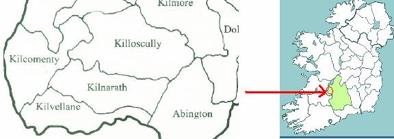
You may be asking yourself why there are four parts to this report. Newport Catholic Parish was composed of most or all of the following four Civil Parishes: Kilnarath, Kilcomenty, Killoscully and Kilvellane (Kilvolane). Our Tipperary ancestors came from this area. The Ryans, Campbells, and Hills lived in Kilnarath. Our great-ancestor, James Camel (Campbell), lived in Killoscully before his marriage to Mary Casey. We see James Camel listed in the Kilnarath tithe records. The Boney family lived in Kilvellane. On the wedding register, we see James Ryan listed residing in Birdhill (Kilcomenty Civil Parish).
Each Civil Parish records will appear in its own report. In this report we concentrate on the records for Kilnarath Civil Parish.
Householder’s Index of Names (FHLC #919006)
The following information was gathered from a microfilm owned by the Family History Learning Center. In the following chart “G’ indicates the surname can be found in the Griffith Valuation Survey for Ireland, which was taken between 1847 and 1864. In addition, the number behind the “G” indicates how many times the surname appears in the list. You will see a “T” if the surname is found in the Tithe Records.
What does the Index show us? First, it tells us if a surname is found in either the Griffith Valuation Survey or the Tithe Applotment Record. Second, it shows a distribution of these surnames between 1823 and 1864. Unfortunately the Tithe Applotment Record does not show people living in towns or cities. The numbers below only indicate those people who leased land in County Tipperary during the early to mid-nineteenth century. Ryans can be found in all parts of County Tipperary.
County Tipperary
|
Surname |
Griffith Valuation Survey |
Tithe Applotment Record |
Barony |
|
Campbell |
G |
T |
Ormond Lr |
|
Campbell |
G |
|
Owney & Arra |
|
Campbell |
G2 |
|
Ikerrin |
|
Campbell |
G |
|
Kinamanagh U |
|
Campbell |
G |
|
Eliogarty |
|
Hill |
G4 |
T |
Ormond Lr |
|
Hill |
G5 |
|
Owney & Arra |
|
Hill |
G10 |
T |
Ormond U |
|
Hill |
G |
|
Kilnamanagh U |
|
Hill |
G |
|
Eliogarty |
|
Boney |
G |
|
Kilnamanagh U |
|
Boney |
G3 |
|
Owney & Arra |
|
McDonald |
G2 |
T |
Ormond U |
|
McDonald |
|
T |
Ikerrin |
|
McDonald |
|
T |
Kilnamanagh U |
|
McDonald |
G2 |
T |
Eliogarty |
|
Ryan |
G135 |
T |
Ormond Lr |
|
Ryan |
G556 |
T |
Owney & Arra |
|
Ryan |
G228 |
T |
Ormond U |
|
Ryan |
G135 |
T |
Ikerrin |
|
Ryan |
G564 |
T |
Kinamanagh U |
|
Ryan |
G490 |
T |
Eliogarty |
What is the Tithe Applotment?
While the Irish census began in 1810, most records were
lost in a fire. The Title Applotment records from 1823-1837 are therefore
extremely important.
The Composition Act of 1823 specified that tithes
due to the Established Church (Church of Ireland), which before had been payable
in kind should now be paid in money. As a result, it was necessary to carry
out a valuation of the entire country, civil parish by civil parish, to
determine how much would be payable by each landholder. This continued for 15
years before ending in 1838. No one was exempt and the tithe was required
payable by Catholics and Protestants alike. As the British took control
of Ireland the Church of Ireland began to push in on the Catholic Church which
had held sway in Ireland for centuries. The Church of Ireland wanted landholders
to pay tithes to the church, and worked on this applotment in order to ensure
that everyone paid.
A book still exists for almost every civil parish in Ireland. It lists the land
in that parish, how it is broken down, who is on each plot of land, and the
amount of money owed. Anyone who leased land had to pay the tithe. Catholics
and non-Anglicans hated the tithe; however, many paid it to maintain their
leasehold.
The population for Kilnarath in 1841 was 3,386 people. The tithe records you see below were dated February 20, 1827.
|
Kilnarath Civil Parish (Newport Catholic Parish) The following description was taken from Lewis’s Topographical Dictionary of Ireland, 1837:
It comprises 5147 statute acres, as applotted under the tithe act, and valued at £4180 per annum; with the exception of an extensive tract of bog, affording excellent fuel, the land is in general of good quality and in an improved state of cultivation. The scenery is of very interesting character; the banks of the river are bold and rocky, presenting some very striking features, and masses of rock lying in its channel give an artificial rapidity to its course. The principal seats are Castle Waller, that of R. Waller, Esq., pleasingly situated in a tastefully embellished demesne; Oakhampton, the property of Lord Bloomfield, and residence of S.W. Philips, Esq.; and Rockvale, the property of the Rev. M. Moore. At Rockvale are considerable flour-mills. The living is a rectory and vicarage, in the diocese of Cashel, united by act of council to the rectories and vicarages of Kilcomenty, Killoscully, and Kilvolane, together constituting the union of Kilnerath, or St. John's Newport, in the patronage of the Archbishop: the tithes amount to £300, and of the entire benefice to £1407 16s.10½d. There is a glebe-house, and the glebe of the union comprises 8½ acres. The principal church of the union is at Newport; there is also a church in the parish of Killoscully.
In the Roman Catholic divisions the parish is the head of two
unions or districts, one called Newport, comprising also
parts of the parishes of Kilvolane and Kilcomenty, in each
of which is a chapel: and the other called Ballynahinch,
comprising also Killoscully, in which latter parish is a chapel.
About 400 children are taught in four private schools. There are some remains of the old church, and also of the chapel of Kilpatrick; near which is a chalybeate spring, not much used.
|
Bleanbeg Bog
One of the natural features of Kilnarath is Bleanbeg Bog, which consists primarily of upland blanket bog. It is approximately 6 miles east of Newport. It is located in the townlands of Bleanbeg, Glencroe, Fiddane and Castle Waller. The land is composed of heath, upland grassland on peaty soil and cutover bog. If you recall, our ancestors came from Gortnaskehy townland, Kilnarath Civil Parish. Gortnaskehy is located between Fiddane and Bleanbeg townlands. The bog would be found south of Gortnaskehy. Bleanbeg Bog is currently managed by County Tipperary as a preserve. No one lives in Bleanbeg now.
Tithe Applotment Records **IMPORTANT**
You will notice several things about the following records. First, we added items of interest when discussing various townlands. Second, some names appear unusual in that they have another name attached to them. These ‘second’ names may refer to a father’s first name, mother’s surname, or a nickname. This was done because there were so many similar names that the enumerators had to determine a way to identify who was who.
Example: James Burke Ryan. (This would indicate the Leaseholder’s name as ‘James Burke’ and that his mother’s surname was possibly ‘Ryan’.)
The following tithe records were transcribed from a microfilm owned by the Family History Learning Center (FHLC #0256651).
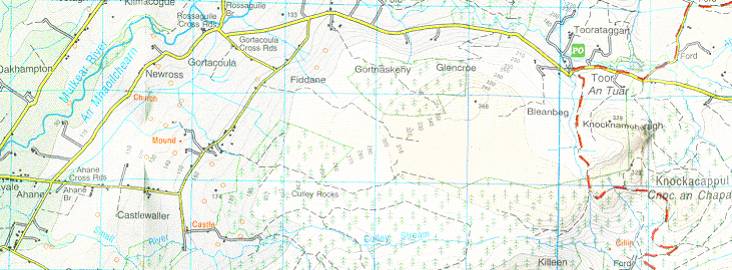
You may find the following map helpful when viewing the tithe records. Gortnaskehy Townland can be found in the top center portion of this map. Gortnaskehy is where the Ryan and Campbell families lived in Ireland. This map shows the area of Ireland which comprises Kilnarath Civil Parish. Knockacappul Townland can be found in the extreme right portion of this map. This townland is where the Hill family lived in Ireland. Near Newross townland is where the old Catholic Church and graveyard are located in Kilnarath. The map’s area is approximately 2 miles by 5 miles. Below Killeen Townland is Lackamore Townland, and this is where the Boney family lived. From Ahane Townland one would travel ½ mile to reach the market town of Newport.
******************************************
Applotment in British Currency in the Amount of * Payable to Rev John Pennefather, Rector of said parish. Composition of the Parish of Kilnarath.
Henry Lee and Wm Pennefather, Esqrs. Commissioners
Dated this 20th Day of February 1827
