

Greenans in Ireland
Our County Monaghan Ancestors
The Greenan Family
Introduction
The family discussed here is the Greenan family. You probably recognize this name if you have followed the Smith family genealogy. Greenan is the maiden name of Irish John Smith’s mother, Catharine (Greenan) Smith. Other variations of this name include Green or Greene. The surname Greenan probably comes from England, possibly southern England, and is not one of the old surnames of ancient Ireland. It is not clear how this family made its way to Ireland or when. Ulster is where they call their home.
This is our Smith family tree:
| Catharine Greenan | ||||
| Peter Smith | Irish John Smith | |||
| William Smith | John W. Smith | |||
| Michael McPhillips | Susan McPhillips | |||
| Mary Smith* |
(* We found one reference to suggest the spelling variation was ‘Smythe’; however, it was probably spelled ‘Smith’.)
Most of what follows are copies of the actual Griffith Valuation documents and copies of the Irish Ordnance maps taken during this period of time. With this information you will see how close these families were to the Smith family of Rossnaglogh East townland.
County Monaghan
County Monaghan in Gaelic is known as ‘Muineachain’ or ‘Place of thickets’. Located in the province of Ulster this County was known for its agriculture, primarily flax. Monaghan is a county of lakes, gentle hills, farmhouses and market towns. Monaghan also is home to several Bronze Age megalithic sites and prehistoric remains.
It comprises an area, according to the Ordnance surveys of 327,048 statute acres, of which 9236 are unimproved mountain and bog, 6167 are under water, and the rest are cultivated land. The population in 1821, amounted to 174,697, and in 1831 the population had jumped to 195,536. Its greatest length southeast by northwest is nearly 40 miles, and its width southwest by east is about 22 miles.
In comparison, McPherson County in South Dakota has 737,000 acres of land. Pennington County in South Dakota has 969,908 agricultural acres alone.
Where Was Catharine Greenan Born?
We don’t know. The only thing we know about her family is that she had at least one brother, Terence Greenan. Terence lived with Catharine Smith and her three children (John, Owen and Bridget) on Walworth Street in Brooklyn, New York. After landing in New York, Terence Greenan adopted the last name of Green. Since we do not know where Catharine was born, lived as child, or where she got married, we have included all Greenan entries found in the Griffith Valuation Index. Sixty-nine Greenan head of households are listed in this index for all of County Monaghan during the years 1847 to 1864.
Aghabog Civil Parish
Aghabog Civil Parish in 1837 was approximately 1 mile west from Newbliss, on the road from Clones to Ballybay. In 1837 there were only 7442 inhabitants in this parish. Aghabog was comprised of 11,543 ½ statute acres of which 10,484 acres were arable and pasture land. Aghabog was ground zero for our Smith ancestors. So we start our search here for any Greenans found in this civil parish.
Look at the map shown above. Aghabog County can be found in the western part of County Monaghan and is labeled with a ‘1’ in the map above. Surrounding civil parishes include Killeevan (15), Currin (6), Ematris (11), Kilmore (16) and Drumsnat (10). Where possible, maps have been added to show you where these ‘possible’ ancestors may have lived. Irish John Smith lived in Rossnaglogh East, Aghabog Civil Parish. This townland is near Kilmore Civil Parish. The two parishes we will review are Aghabog and Kilmore. The last section will be a hodgepodge of other parishes within County Monaghan where other Greenans lived. The following information is taken from Griffith’s Valuation Index and the Irish Ordnance maps.
AGHABOG CIVIL PARISH – Greenan Records
The following Greenan records were found in the Griffith Valuation Index. Printing dates for these records varied from 1847 to1864; however, this does not mean the information found in the index was always completely reliable. In some cases the index contained persons who had died during the ‘Great Hunger’, which suggests the information was not always updated during each new printing run. The following names appear in the Griffith Valuation Index for Aghabog Civil Parish.
|
GREENAN |
JAMES |
DUFFY |
JOHN |
MONAGHAN |
AGHABOG |
DRUMAGHAKEEL |
|
GREENAN |
THOMAS |
PLUNKETT |
THE RIGHT HON.& RIGHT REV.LORD |
MONAGHAN |
AGHABOG |
FALTAGH |
|
GREENAN |
PATRICK |
LEWIS |
ARTHUR G. |
MONAGHAN |
AGHABOG |
LISCUMASKY |
We copied the Griffith Valuation records for your review and analysis. It is possible that some of these names you see are also distant relatives of ours. We highlighted sections of the following maps to show you where these people lived and will indicate, if applicable, where they lived in relation to any possible relatives.
James Greenan of Drumaghakeel Townland
 |
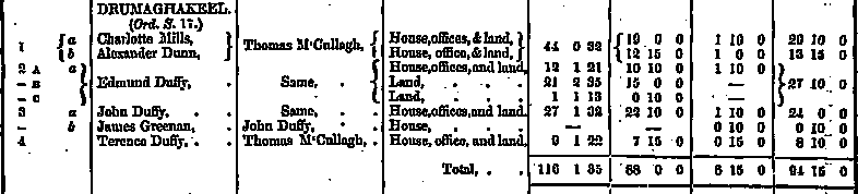 |
James Greenan lived in Aghabog in a Drumaghakeel townland. Drumaghakeel looks to be perhaps less than a mile distance from Newbliss. Newbliss is one of the main market towns in this part of County Monaghan. According to the information above, James had a house and perhaps an office and land. As you can see there were few people living in this townland. The following shows relevant information for Drumaghakeel.
|
Townland |
AKA |
Acres |
County |
Barony |
Civil Parish |
PLU |
Province |
|
Drumaghakeel |
|
116 |
Monaghan |
Dartree |
Aghabog |
Cootehill |
Ulster |
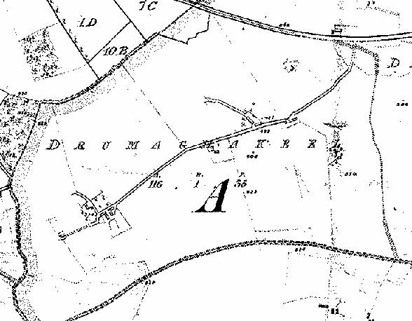
Unfortunately, the map below does not tell us much regarding where he lived. The map shows the layout for Drumaghakeel townland. Looking at this map it appears there are a cluster of buildings located at the lower left portion of this map. Many townland maps contain ‘numbers’ which help to locate people. For whatever reason the numbers on this map are missing for Drumaghakeel, but suffice it to say that James Greenan lived somewhere within this townland of 116 acres.
Thomas Greenan of Faltagh Townland
 |
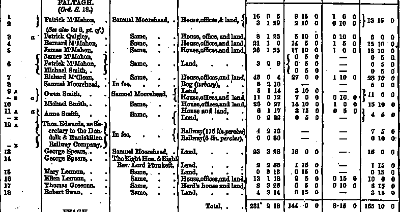 |
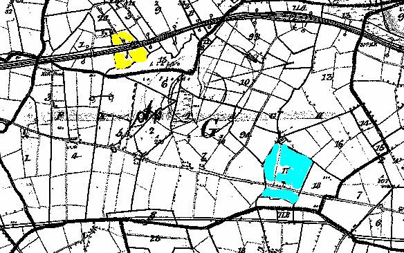
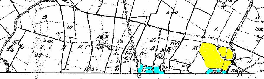
From this information above we see an entry for ‘Thomas Greenan’ who lived in Faltagh Townland. Faltagh can be found on a map below and adjacent to Rossnaglogh East, Irish John’s home townland. According to the information above, Thomas Greenan occupied a herd’s house and held approximately 15 acres of land. In reviewing the index we can see he occupied land that is referenced by ‘17’ on the Irish Ordnance map. Below, is a copy of this map. Please note the two colors used for highlighting. The first land highlighted in ‘yellow’ is found in Rossnaglogh East and was occupied by John Smith. The second piece of land highlighted in blue was occupied by Thomas Greenan. His house was a short walk from Rossnaglogh East. If you have already read the piece about the Smith family you will also know that Thomas Greenan lived only a few hundred feet away from other Smith families. (See Our County Monaghan Ancestors – The Smith Family. Section 9A, for example, was occupied by Owen Smith.)
The following shows the relevant information for Faltagh townland:
|
||||||||||||||||
 |
Patrick Greenan of Liscumasky Townland
 |
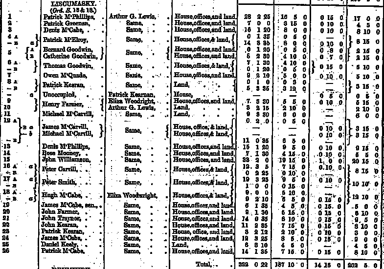 |
This appears to be an incomplete map of Liscumasky townland, but it is the only one which we have been able to find. The next townland west from Liscumasky is Lathnamard, which is where the Roman Catholic chapel is located in Aghabog. This may have been the parish church which the Smiths attended. According to the Griffith Valuation Index, Patrick Greenan should be found in section 2 of this map. Patrick’s land is highlighted in ‘yellow’. Now, there is something else of interest on this map that you should be aware.
The Griffith Valuation was taken between the years 1847 and 1864. From Irish John Smith’s own hand he wrote that his father died in1847. What is interesting about the following map is it shows a ‘Peter Smith’ living next door to Patrick Greenan. Peter Smith was the name of Irish John’s father. The Griffith Valuation Index was known to also include entries of people who had died during the ‘Great Famine’. Although these ‘books’ were reprinted several times, there was no record that any of these entries had been updated since the first time they were gathered. Is this ‘Peter Smith’ Irish John’s father? More research is underway. Liscumasky townland was perhaps a mile or so away from Rossnaglogh townland.
The following information shows general information regarding this townland.
|
||||||||||||||||
 |