

The McGonigles
Our County Donegal Ancestors
The McGonigle Family
County Donegal
This Ulster coastal county, which is largely bog and mountain land, contains the towns of Letterkenny, Donegal, Ballyshannon, Lifford, Stranorlar, Killybegs, and Bundoran. In 1837 the following description was written about Killybegs: KILLYBEGS, a sea-port, market, and post-town, and a parish, (formerly a parliamentary borough), partly in the barony of BOYLAGH, but chiefly in that of BANNAGH, county of DONEGAL, and province of ULSTER, 38 miles (S. W.) from Lifford and 127 miles (N. w.) from Dublin, on the road from Ballyshannon and Donegal town to Rutland ; containing 4287 inhabitants, of which number, 724 are in the town. County Donegal contains 4,830 square kilometers of land. (Compare this to Brule County, South Dakota, which has 2,192 square kilometers of land with 5,364 people.)
The parish, from which a portion (38 townlands) has been separated to form the district parish of Ardara, is for civil purposes distinguished into Upper and Lower Killybegs. It comprises, according to the Ordnance survey, 30,962 ½ statute acres, of which 4304¼ are in that part of Lower Killybegs, which is in the barony of Boylagh ; 11,074¼ , including a detached portion, and 51 covered with water, are in the other part, in the barony of Bannagh ; and 15,583¾ , including 41¾ covered with water, are in Upper Killybegs, and the barony of Bannagh : 30,160 statute acres are applotted under the tithe act, of which about two-thirds are mountain and uncultivated land : agriculture is in a very unimproved state.
Family Tree
Why should we know where our ancestors lived? Armed with this information we can find out how they lived, a description of the land they inhabited, and a starting point for further genealogical research. The following shows our family tree from County Donegal. We are kin to this family through Adelaide McGonigle.

![[home]](new_page_21_files/image003.gif)
The Griffith Valuation Survey
The first modern census for Ireland began in 1821 and a census was taken every 10 years. War and fires destroyed most Irish census records, and the earliest records to be found are dated 1901. Due to this lack of census information genealogists rely on ‘census substitutes’ such as the Griffith Valuation Survey when seeking distant relatives. Had the census records survived this survey would have been long forgotten.
Peter McGonigle of Drumbarity Townland
Family tradition says Francis (Frank) McGonigle knew Catherine Murrin in County Donegal. What clues do we have where Francis McGonigle lived in Ireland? We know his father’s name was Peter and we also know he came from the Killybegs area. Armed with this information we searched for where Francis McGonigle and his family lived in County Donegal. One way to search for Irish ancestors is to consult the Griffith Valuation Survey, which is an Irish ‘Census Substitute’ taken between 1847 and 1864.
The Griffith Valuation was used to assess taxes and it shows the head of households only. Frank McGonigle would have been too young to be listed on this list even by late 1864; however, Peter McGonigle’s name should appear. We searched for any reference to ‘Peter McGonigle’ in County Donegal and found the following three entries in the Griffith Valuation Survey. In addition, the index also shows the name of the landlord.
|
MCGONIGLE |
PETER |
YOUNG |
GEORGE |
DONEGAL |
CULDAFF |
BALLEEGHAN, LOWER |
|
MCGONAGLE |
PETER |
MACNAUGHTAN |
JOHN |
DONEGAL |
GLENCOLUMBKILLE |
MEENADREEN |
|
MCGONIGLE |
PETER |
SPILLER |
|
DONEGAL |
KILLYBEGS, UPPER |
DRUMBARITY |
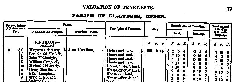
Two of these entries are outside of the Killybegs area; however, there is a listing for Peter McGonigle living in the Upper Killybegs Civil Parish, Drumbarity townland. Mrs. Spiller owned the land where Peter McGonigle and his family lived. This townland was not very big and only had 67 acres of land. Seven families lived in this location. Peter McGonigle, according to the description of this tenement, had a house, office and land on four acres. The townland was located on the outskirts of Corporation/ Killybegs town. What you see below is a copy of the valuation document as published in the mid-nineteenth century.
|
Townland |
AKA |
Acres |
County |
Barony |
Civil Parish |
PLU |
Province |
|
Drumbarity |
|
67 |
Donegal |
Banagh |
Killybegs Upper |
Glenties |
Ulster |

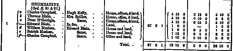
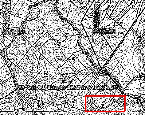 |
To your side is a map showing the upper portion of Drumbarity townland. The area within the red rectangle is most likely where Peter McGonigle lived.
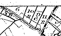
Where is Drumbarity located? Just south of Drumbarity is Drumbeagh townland. South and adjacent to Drumbeagh townland is Killybegs market town; therefore, Drumbarity is located on the outskirts of Killybegs but is still considered rural country. The distance between Drumbarity and Killybegs town appears to be approximately ½ mile, perhaps less.
|
 |
This map is taken from another map of
|
***
It is also interesting to note that the 1659 Poll Money Ordinance shows a Richard m’Congill living in a townland called Drumbourty in Killbeggs parish. The ‘McGonigle’ surname shows many spelling variations over the years. Drumbourty and Drumbarity are variations for the same place name.
***
McGonigle Family
Please note the other McGonigles found in Upper Killybegs during the mid-nineteenth century. The following lists the McGonigle names found in the Griffith Valuation Survey from 1847 to 1864. At first glance it appears there a lot of people with the same first and last name. The index only shows a listing of land parcels and tenement. As you shall see later, the same person may be listed several times in this list because they are tenement farmers working various parcels of land. If the survey taker found two different people with the same name, the survey was marked to identify this point. They would indicate these differences by adding the mother’s last name, nickname, physical characteristic or other characteristic to the occupier’s name. In the list below you see ten names; however, after eliminating duplicates there really are only six McGonigles who are listed as heads of household in Upper Killybegs.
Look at the list below. Three names capture our attention and they are Francis McGonigle, Peter McGonigle and Myles McGonigle. Peter’s name grabs us because that is the name of our great ancestor. The other two names figure in our family history. Adelaide McGonigle’s father (and our ancestor) was named Francis. The entry below is not for Adelaide’s father, but he may be someone in our family line. Our ancestor Francis McGonigle lived with a Miles McGonigle in Colorado. Who is this ‘Myles McGonigle’ that we see in the list below?
|
MCGONIGLE |
PATRICK |
STEWART |
H.G.MURRAY |
DONEGAL |
KILLYBEGS, UPPER |
BALLYARA |
|
MCGONIGLE |
FRANCIS |
STEWART |
H.G.MURRAY |
DONEGAL |
KILLYBEGS, UPPER |
BALLYARA |
|
MCGONIGLE |
FRANCIS |
STEWART |
H.G.MURRAY |
DONEGAL |
KILLYBEGS, UPPER |
BALLYARA |
|
MCGONIGLE |
PATRICK |
STEWART |
H.G.MURRAY |
DONEGAL |
KILLYBEGS, UPPER |
BALLYARA |
|
MCGONIGLE |
PATRICK |
STEWART |
H.G.MURRAY |
DONEGAL |
KILLYBEGS, UPPER |
BALLYARA |
|
MCGONIGLE |
MARGARET |
STEWART |
H.G.MURRAY |
DONEGAL |
KILLYBEGS, UPPER |
BALLYARA |
|
MCGONIGLE |
MARGARET |
STEWART |
H.G.MURRAY |
DONEGAL |
KILLYBEGS, UPPER |
BALLYARA |
|
MCGONIGLE |
PETER |
SPILLER |
|
DONEGAL |
KILLYBEGS, UPPER |
DRUMBARITY |
|
MCGONIGLE |
ANNE |
HAMILTON |
ANNE |
DONEGAL |
KILLYBEGS, UPPER |
FINTRAGH |
|
MCGONIGLE |
MYLES |
CONOLLY |
THOMAS |
DONEGAL |
KILLYBEGS, UPPER |
KILLYBEGS |
The McGonigles of Ballyara Townland
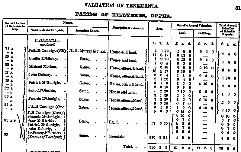
Seven McGonigle listings are found in the Griffith Valuation Survey for Ballyara townland. We included the full Valuation list for this townland because it contains a lot of names. Ballyara is a large townland of approximately 960 acres. Where is Ballyara? Ballyara is four townlands northwest of Killybegs market town, but not a great distance away. Midway between Ballyara and Killybegs is Drumbarity, where Peter McGonigle lived. Looking at the map one can see that Ballyara is only one townland over from Drumbarity.
|
Townland |
AKA |
Acres |
County |
Barony |
Civil Parish |
PLU |
Province |
|
Ballyara |
|
900 |
Donegal |
Banagh |
Killybegs Upper |
Glenties |
Ulster |



Two pages were required to list all the tenants of this large townland. Many names are repeated here, and no McGonigle name appears with a secondary identifier. As an example, look at the entries for Margaret McGonigle above. Since there is no further identifier listed by the enumerator, we can assume these two entries refer to the same person.
Maps of Ballyara Townland
The following maps show various sections of this townland. Due to its large size it was necessary to break up this townland in order to show which land the McGonigles occupied. Only a quarter of this townland’s land mass appears in the map below.

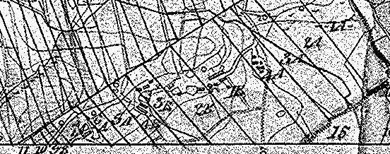
Above we see only a partial map of Ballyara townland. Can you find these names and associated land parcel numbers: (1) Patrick McGonigle (6B); Margaret McGonigle (19B); Margaret McGonigle (20 B); and Patrick McGonigle (32A)?
 |
|
 |
This section is found on the west side of Ballyara.
Francis McGonigle lived in section 30.
Again, this little section seems to indicate buildings, which
could be where Francis McGonigle lived in this part of
|
 |
The map below shows another view of the same townland. The Griffith Valuation Survey shows the following information: Patrick McGonnigle (6A, 6B, 32A, 32 B); Margaret McGonigle (19A, 19B); Francis McGonigle (32A, 32B). Francis McGonigle’s land will not be seen on this map. From this information we gather that Francis and Patrick shared the same land. It is also possible Margaret may have been a widow. |
The McGonigles of Fintragh Townland
Fintragh is a very large townland and we only present a portion of the Griffith record for your review. This townland appears to be located in a mountainous region in County Donegal, and is northwest of Ballyara townland. Although it shows a larger than normal land area, it only contains a small number of residents. How small was the population? The list you see below shows half the head of households living in this townland. The map below shows a small town located within this townland. Perhaps this is where these residents lived.
|
Townland |
AKA |
Acres |
County |
Barony |
Civil Parish |
PLU |
Province |
|
Fintragh |
|
3,145 |
Donegal |
Banagh |
Killybegs Upper |
Glenties |
Ulster |

|
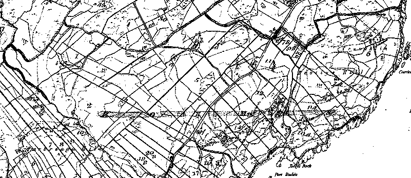
Fintragh townland is located northwest of Killybegs market town. It is possible Anne McGonigle lived within a cluster of other houses. There is a small town indicated on the map and we have copied it here for you. Unfortunately, it is not labeled as other maps; therefore, we do not know where she actually lived. |
The McGonigles of Killybegs market town
The following was taken from an 1837 description of Killybegs: The town is situated at the head of a beautiful and safe harbour, to which it gives name, and at the base of a vast mountainous tract extending northward; and consists of 126 houses. It is the head of a coast-guard district, comprising the stations of Dooran, Tribane, Tiellen-East, Tiellen-West, Mallinbeg, Daurus, Port Noo, and Neptune Tower, with a force of four officers and 56 men, under the control of a resident inspecting commander. A constabulary police force is also stationed here. The market is on Tuesday, and fairs are held on Jan. 15th, Easter-Monday, May 6th, June 2lst, Aug. 12th, Sept. 15th, and Nov. 12th, for general farming stock. The harbour is nearly circular in form, well sheltered, and accessible to ships of considerable burden; vessels not drawing more than ten feet of water may anchor near the town, but the best anchorage is in 8½ fathoms near the west side At sea the harbour is known by the remarkably sharp pointed summit of Cruanard Hill, which is higher than any other in the neighbourhood, and to the south of which is the entrance.
In 1881 Colorado Francis McGonigle was shown to have lived with a Miles McGonigle and William McGonigle. The Valuation Survey below lists a ‘Myles McGonigle’ living off of Fintragh Road. Miles and Myles are not the same person. The Miles McGonigle family also has its family lore. They claim Miles smuggled himself aboard ship to America as a teenager. Is this Myles McGonigle found in the list below a distant relative?
|
Townland |
AKA |
Acres |
County |
Barony |
Civil Parish |
PLU |
Province |
|
KILLYBEGS T. |
|
xx |
Donegal |
Banagh |
Killybegs Upper |
Glenties |
Ulster |
|
Killybegs |
|
325 |
Donegal |
Banagh |
Killybegs Upper |
Glenties |
Ulster |


 |
This map only shows a section of Killybegs market town.
According to The Valuation of Tenements, Myles McGonigle lived in
a building with a reference code of ‘7’.
We have circled this house on the map.
According to the Griffith Valuation Index, Myles lived on
|
Tithe Applotment - 1834
The Composition Act of 1823 specified that tithes due to the Established Church, the Church of Ireland, which before had been payable in kind, should now be paid in money. As a result, it was necessary to carry out a valuation of the entire country, civil parish by civil parish, to determine how much would be payable by each landholder. This was done over the ensuing 15 years, up to the abolition of tithes in 1838. No one was exempt and the tithe was required payable by Catholics and Protestants alike. The following McGonigle names appear on the Tithe Applotment list of 1834 for Killybegs Upper Civil Parish:
McGonigle Daniel, Rushin
McGonigle Farigle, Knockahenny
McGonigle Francis, Gortnamuck
The Griffith Valuation Survey did not list Daniel and Farigle; however, the Griffith Valuation lists a Francis McGonigle. It is possible we see the same person listed on the Tithe Applotment list as we see in the Griffith Valuation Survey. It is possible Daniel and Farigle McGonigle may have been alive during the mid-nineteenth century too, but living with one of their children.
We could not find Knockahenny listed as a placename; therefore, we assume it was an old placename not in vogue during the time when the Griffith Valuation Survey was taken. We could find Gortnamuck and Roshin (possibly a variation of ‘Rushin’). Gortnamuck appears to be a placename for a section of Donegal and is not a townland name.
 |
The map to the side shows ‘Gortnamuck’, which is located just west of Killybegs town. Gortnamuck is not a townland but appears to describe a region for this section of Donegal. Ballyara is found northeast of Gortnamuck, perhaps only a quarter mile away.
Below you will find a map of Roshin townland. Roshin (or Rushin) can be found just south of Killybegs town, and appears to be adjacent to and south of Killybegs townland.
|
(An interesting side note is we found a Fergill Congill living in ‘Killbegg' parish. This name was listed in the 1655 Hearth Roll Tax. Obviously, this is not the same person, but might suggest a family first name passed down through the generations.)
Conclusion
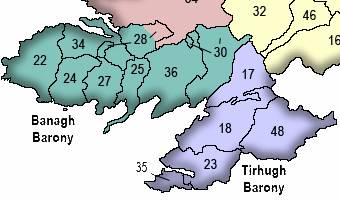
Were any or all of these McGonigles distant relatives of ours? Very like some of the names found here are related to our family. These parishes were not extremely large and it is also likely the McGonigle family had relatives in nearby parishes.
 |
The map to the side shows the lower portion of
|
|
MCGONIGLE |
NEAL |
HAMILTON |
JAMES |
DONEGAL |
INISHKEEL |
BELLANAMORE |
|
MCGONIGLE |
WILLIAM |
TREDENNICK |
WILLIAM R. |
DONEGAL |
KILLAGHTEE |
AIGHAN |
|
MCGONIGLE |
JOHN |
CASSIDY |
SARAH |
DONEGAL |
KILLAGHTEE |
CALHAME |
|
MCGONNIGLE |
WILLIAM |
WALSH |
JOSEPH |
DONEGAL |
KILLAGHTEE |
CASHELREAGH GLEBE |
|
MCGONAGLE |
STEPHEN |
STEWART |
H.G.MURRAY |
DONEGAL |
KILCAR |
DERRYLAHAN |
|
MCGONIGLE |
JAMES |
LABATT |
EDWARD |
DONEGAL |
KILCAR |
ROXBOROUGH GLEBE |
One final note about the lists shown above. The 1881 Colorado Business Index lists the following teamsters: William McGonnigle, Francis McGonnigle and Miles McGonnigle. Notice the extra ‘en’ in the McGonigle surname. This variation was found in a listing for Killaghtee Civil Parish, which lists a William McGonnigle as a tenant. We do have maps and copies of the Griffith Valuation Survey for these McGonigles, and can provide these to you if requested.