

Our County Monaghan Ancestors
Smith Family
The Smiths claim they can trace their lineage to ‘Russnaglogh’ in County Monaghan. Census returns for Ireland prior to 1901 were destroyed by either fire or war; therefore, genealogists use ‘census substitutes’ for tracing ancestors. One well known census substitute is the Griffith Valuation Index, which was taken between 1847 and 1864. This index was used to determine tax values based on the land one lived on regardless of whether owned or leased. Typically, the head of household was listed in this Index.
This is our Smith family tree:
Catharine Greenan __
|___ ‘Irish’ John Smith ____
| |
Peter Smith ________ | |
| _____ William Smith
Michael McPhillips __ |
|___ Susan McPhillips _____ |
|
Mary Smith * ______ |
(* One source suggests the spelling to be ‘Smythe’; however, from the McPhillips family we understand this spelling to be ‘Smith’.)
Below, twelve Smith names appeared on the Griffith Valuation Index for Civil Parish Aghabog. Our line of Smiths can trace its ancestry to Rossnaglogh East. East of and abutting Rossnaglogh East is Corravilla townland. Corravilla was also the homeland for Susan McPhillips.
|
SMITH |
EDWARD |
WESTENRA |
MISS H. |
MONAGHAN |
AGHABOG |
CORRAVILLA |
|
SMITH |
MARY |
WESTENRA |
MISS H. |
MONAGHAN |
AGHABOG |
CORRAVILLA |
|
SMITH |
EDWARD |
WESTENRA |
MISS H. |
MONAGHAN |
AGHABOG |
CORRAVILLA |
|
SMITH |
ALICE |
ROSSMORE |
LORD |
MONAGHAN |
AGHABOG |
DRUMLINNY |
|
SMITH |
MICHAEL |
MOOREHEAD |
SAMUEL |
MONAGHAN |
AGHABOG |
FALTAGH |
|
SMITH |
OWEN |
MOOREHEAD |
SAMUEL |
MONAGHAN |
AGHABOG |
FALTAGH |
|
SMITH |
MICHAEL |
MOOREHEAD |
SAMUEL |
MONAGHAN |
AGHABOG |
FALTAGH |
|
SMITH |
ANNE |
MOOREHEAD |
SAMUEL |
MONAGHAN |
AGHABOG |
FALTAGH |
|
SMITH |
PATRICK |
ROSSMORE |
LORD |
MONAGHAN |
AGHABOG |
GENAGH |
|
SMITH |
PETER |
LEWIS |
ARTHUR G. |
MONAGHAN |
AGHABOG |
LISCUMASKY |
|
SMITH |
MARY |
ELLIS |
THOMAS C. |
MONAGHAN |
AGHABOG |
RAKEEVAN |
|
SMITH |
JOHN |
LEWIS |
ARTHUR G. |
MONAGHAN |
AGHABOG |
ROSSNAGLOGH, EAST |
ROSSNAGLOGH EAST
The following Griffith Valuation Index entries were found for ‘Rossnaglogh East’ in Aghabog Civil Parish:


We see one entry for John Smith.
FALTAGH
Next, we will look at the Smith entries for neighboring Faltagh townland:


What do we see here? We see four Smith entries in this Valuation Index for Faltagh townland. According to this information Michael Smith had some acres of land in Section 6 but no building. Owen Smith had a house, offices and farmed 11 acres of land. His land can be found on the Ordnance map in Sections 9A and 9B. Michael Smith’s name appears again and this time it shows he has 15 acres with a house and office. Anne Smith had 4 acres of ratable property but does not indicate she had a house.
The Smith families of Faltagh and Rossnaglogh East lived next to each other, which would suggest they all were related.
ROSSNAGLOGH EAST, FALTAGH and CORRAVILLA TOWNLANDS
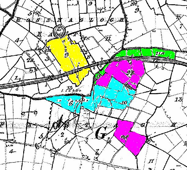
Rossnaglogh East:
John Smith Sections 9A and 9 B (yellow)
Faltagh:
Michael Smith Sections 6 and 10 (light blue)
Owen Smith Sections 9A and 9B (purple)
Anne Smith Sections 11A and 11B (green)
The acreage farmed by the Faltagh Smith families may have been larger than what I highlighted, but I wanted to show you the general location for everyone to see clearly the relationship between these families. Because of its proximity I would strongly suspect all these Smith families were related. Corravilla townland, by the way, can be found directly above the shaded 11A area found on the map. If you look on this map close enough you can also see the farmsteads with buildings.
CORRAVILLA
Now, let us look at Corravilla townland which is right next to Rossnaglogh East. The Griffith Valuation for Corravilla townland is as appears below:

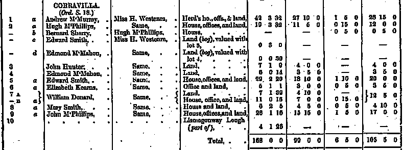
From this information we see three Smith entries; however, they refer to only two people – Edward and Mary Smith. Edward’s tenement includes a bog (Section 2C) as well as a house, office and land (Section 5A). Mary Smith has a house and land and this can be found in Section 8A of the Ordnance Map. Notice also entries for two McPhillips – Hugh McPhillips and John McPhillips. Are any of these McPhillips families related to us? We do not know for sure. Recent information we have gained suggests Susan McPhillips family was not originally from this area. Her grandfather’s name was Patrick.
The Ordnance map for their land in CORRAVILLA TOWNLAND appears as below:
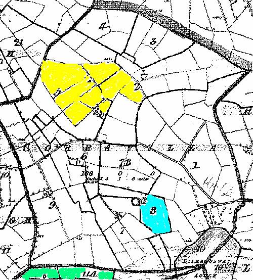
CORRAVILLA TOWNLAND:
Edward Smith Sections 2C and 5A
Mary Smith Sections 8A
FALTAGH TOWNLAND
Anne Smith Section 11A
We referred to Anne Smith’s land above when discussing the Smiths of Rossnaglogh East and Faltagh townlands. Because of their proximity, it is possible that Mary and Edward Smith are also related to this Smith grouping, even if only distantly. So now we have seen eight of the 11 Smith entries for Aghabog Civil Parish. Let us examine the remaining three entries.