

Smiths in Ireland
Our County Monaghan Ancestors
The Smith Family
You may think much of what we have written is quite dry as it discusses people long dead, placenames lost to memory, and in a land unfamiliar to us. Sometimes it is difficult to know how all this information is relevant. In this document we attempt to use maps when describing family history. For me at least, I can see something more clearly when I am shown a picture. Then it begins to make some sense to me. Hopefully, the information that follows will give you some insight to our family’s origin. Maps are included as well as copies of the original ‘census substitute’ documents.
As you know, we can trace our heritage to at least three different families in County Monaghan: Smith, McPhillips and Greenans. Our ancestors lived in Aghabog Civil Parish, which is sometimes shown as Aughabog Civil Parish. Each family group is discussed in its own section. First, we discuss the Smith family. Later documents will discuss the McPhillips and Greenan families of Aghabog. When relevant we will also reference these family groups.
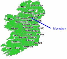
County Monaghan
County Monaghan in Gaelic is known as ‘Muineachain’ or ‘Place of thickets’. Located in the province of Ulster this County was known for its agriculture, primarily flax. Monaghan is a county of lakes, gentle hills, farmhouses and market towns. Monaghan also is home to several Bronze Age megalithic sites and prehistoric remains.
It comprises an area, according to the Ordnance surveys of 327,048 statute acres, of which 9236 are unimproved mountain and bog, 6167 are under water, and the rest are cultivated land. The population in 1821, amounted to 174,697, and in 1831 the population had jumped to 195,536. Its greatest length southeast by northwest is nearly 40 miles, and its width southwest by east is about 22 miles.
Aghabog Civil Parish
Family lore tells us our family traces its lineage to County Monaghan. From Irish John’s own hand he writes that his family was from ‘Russnaglogh’. We also understood Susan McPhillips’s family lived perhaps less than 14 miles from Irish John’s family in a townland called ‘Corravilla’. With this information we found two townlands in Aghabog Civil Parish which were next to each other – Rossnaglogh East and Corravilla.
 |
 |
| You
will find the two maps below helpful.
One map shows
|
|
Barony of Dartree: Below, you can see the placement of Aghabog Civil Parish to
some of the leading towns found in 1831
|
 |
Aghabog Civil Parish in 1837 was approximately 1 mile west from Newbliss, on the road from Clones to Ballybay. In 1837 there were only 7442 inhabitants in this parish. Aghabog was comprised of 11,543 ½ statute acres of which 10,484 acres were arable and pasture land.
Smith Family
The Smiths claim they can trace their lineage to ‘Russnaglogh’. Census returns for Ireland prior to 1901 were destroyed by either fire or war; therefore, genealogists use ‘census substitutes’ for tracing ancestors. One well known census substitute is the Griffith Valuation Index, which was taken between 1847 and 1864. This index was used to determine tax values based on the land one lived on regardless of whether owned or leased. Typically, the head of household was listed in this Index.
This is our Smith family tree:
Catharine Greenan __
|___ ‘Irish’ John Smith ____
| |
Peter Smith ________ | |
| _____ William Smith ______ John W. Smith
Michael McPhillips __ |
|___ Susan McPhillips _____ |
|
Mary Smith * ______ |
(* One source suggests the spelling to be ‘Smythe’; however, from the McPhillips family we understand this spelling to be ‘Smith’.)
Below, twelve Smith names appeared on the Griffith Valuation Index for Civil Parish Aghabog. Our line of Smiths can trace its ancestry to Rossnaglogh East. East of and abutting Rossnaglogh East is Corravilla townland. Corravilla was also the homeland for Susan McPhillips. South of an abutting Rossnaglogh East is Faltagh townland. Drumlinny townland is directly north of and abutting Corravilla townland. Rakeevan and Genagh townlands are near Newbliss, possibly no further than 1 or 2 miles. This would place these two townlands at some distance from Rossnaglogh East. The last townland unmentioned is Liscumasky. Here we find a reference to a Peter Smith.
Peter Smith was Irish John’s father. Is this a reference to Irish John’s father? The Valuation Index is for 1847 to 1864, and Irish John thought his father had died in 1847. Liscumasky is also nearby Lathamard townland. Lathamard is the site of the only Roman Catholic chapel in the parish. I am adding the full Griffith Valuation Index for each townland listed below since it is also possible many of these names are also distant relations to us.
|
SMITH |
EDWARD |
WESTENRA |
MISS H. |
MONAGHAN |
AGHABOG |
CORRAVILLA |
|
SMITH |
MARY |
WESTENRA |
MISS H. |
MONAGHAN |
AGHABOG |
CORRAVILLA |
|
SMITH |
EDWARD |
WESTENRA |
MISS H. |
MONAGHAN |
AGHABOG |
CORRAVILLA |
|
SMITH |
ALICE |
ROSSMORE |
LORD |
MONAGHAN |
AGHABOG |
DRUMLINNY |
|
SMITH |
MICHAEL |
MOOREHEAD |
SAMUEL |
MONAGHAN |
AGHABOG |
FALTAGH |
|
SMITH |
OWEN |
MOOREHEAD |
SAMUEL |
MONAGHAN |
AGHABOG |
FALTAGH |
|
SMITH |
MICHAEL |
MOOREHEAD |
SAMUEL |
MONAGHAN |
AGHABOG |
FALTAGH |
|
SMITH |
ANNE |
MOOREHEAD |
SAMUEL |
MONAGHAN |
AGHABOG |
FALTAGH |
|
SMITH |
PATRICK |
ROSSMORE |
LORD |
MONAGHAN |
AGHABOG |
GENAGH |
|
SMITH |
PETER |
LEWIS |
ARTHUR G. |
MONAGHAN |
AGHABOG |
LISCUMASKY |
|
SMITH |
MARY |
ELLIS |
THOMAS C. |
MONAGHAN |
AGHABOG |
RAKEEVAN |
|
SMITH |
JOHN |
LEWIS |
ARTHUR G. |
MONAGHAN |
AGHABOG |
ROSSNAGLOGH, EAST |
ROSSNAGLOGH EAST
The following Griffith Valuation Index entries were found for ‘Rossnaglogh East’ in Aghabog Civil Parish:
 |
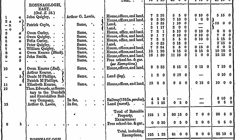 |
According to the information above, we can see a single entry for Smith – John Smith. Who was this ‘John Smith’? Although a slight possibility is that this ‘John Smith’ was Irish John’s grandfather, we suspect he was actually Irish John’s uncle. In fact, there is only one ‘John Smith’ listed for the whole parish. From this information we can see John Smith’s land was found on an Ordnance map in sections ‘9a’ and ‘9b’. He farmed 16 acres of land. Remember this information as we will be looking at a map later.
FALTAGH
Next, we will look at the Smith entries for neighboring Faltagh townland:
 |
 |
What do we see here? We see four Smith entries in this Valuation Index for Faltagh townland. According to this information Michael Smith had some acres of land in Section 6 but no building. Owen Smith had a house, offices and farmed 11 acres of land. His land can be found on the Ordnance map in Sections 9A and 9B. Michael Smith’s name appears again and this time it shows he has 15 acres with a house and office. Anne Smith had 4 acres of ratable property but does not indicate she had a house.
The Smith families of Faltagh and Rossnaglogh East lived next to each other, which would suggest they all were related.
Please note in the Faltagh valuation there lived a Thomas Greenan. Was he a relative?
ROSSNAGLOGH EAST, FALTAGH and CORRAVILLA TOWNLANDS

Rossnaglogh East:
John Smith Sections 9A and 9 B (yellow)
Faltagh:
Michael Smith Sections 6 and 10 (light blue)
Owen Smith Sections 9A and 9B (purple)
Anne Smith Sections 11A and 11B (green)
The acreage farmed by the Faltagh Smith families may have been larger than what I highlighted, but I wanted to show you the general location for everyone to see clearly the relationship between these families. Because of its proximity I would strongly suspect all these Smith families were related. Corravilla townland, by the way, can be found directly above the shaded 11A area found on the map. If you look on this map close enough you can also see the farmsteads with buildings.
CORRAVILLA
Now, let us look at Corravilla townland which is right next to Rossnaglogh East. The Griffith Valuation for Corravilla townland is as appears below:
 |
 |
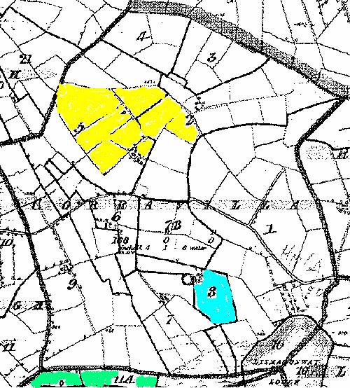
From this information we see three Smith entries; however, they refer to only two people – Edward and Mary Smith. Edward’s tenement includes a bog (Section 2C) as well as a house, office and land (Section 5A). Mary Smith has a house and land and this can be found in Section 8A of the Ordnance Map. Notice also entries for two McPhillips – Hugh McPhillips and John McPhillips. Are any of these McPhillips families related to us? We do not know for sure. Recent information we have gained suggests Susan McPhillips family was not originally from this area. Her grandfather’s name was Patrick.
The Ordnance map for their land in CORRAVILLA TOWNLAND appears as below:
CORRAVILLA TOWNLAND:
Edward Smith Sections 2C and 5A
Mary Smith Sections 8A
FALTAGH TOWNLAND
Anne Smith Section 11A
We referred to Anne Smith’s land above when discussing the Smiths of Rossnaglogh East and Faltagh townlands. Because of their proximity, it is possible that Mary and Edward Smith are also related to this Smith grouping, even if only distantly. So now we have seen eight of the 11 Smith entries for Aghabog Civil Parish. Let us examine the remaining three entries.
DRUMLINNY TOWNLAND – Alice Smith
 |
 |
There is one Smith entry for Drumlinny townland and that is for ‘Alice Smith’. The information here says she farms 3 to 4 acres of land, but has no house. Unfortunately, I looked at the accompanying Ordnance map and it does not indicate where any of these people farmed or lived, save Peter McCarvill, who farmed in Section 2. I added the following map so you can see where it is in relation to Corravilla and Rossnaglogh East.
DRUMLINNY TOWNLAND

Other Smith Families in Aghabog Townland
Outside the large Ordnance map but still in Aghabog Civil Parish are three other Smith families that we need to review. The first is Patrick Smith of Genagh Townland. Patrick Smith had a small acreage of land and a house found in Section 6 of the Ordnance map. He lived some distance from John Smith in Rossnaglogh East townland. Is it possible this Patrick Smith is related to our family? From the US Census of 1920 we can see a Patrick Smith living with Irish John and his family. He is described as a cousin who was born in Scotland. This will be discussed later.
GENAGH
 |
 |
Mary Smith lived in Rakeevan townland; however, she was no further than a mile from Newbliss and lived next door to a different Civil Parish. Because of this distance it is likely she was related to a Smith family closer to Newbliss and not connected with our family in any way.
 |
Rakeevan Townland is shown in the map below.
Mary Smith lived in this townland.
Next to it on right is Genagh townland, which is only partially shown in
this map. Patrick Smith lived in
Section 6, which is not shown in this map. Newbliss, a major market town, is no further than a mile away from here. It is possible that it is only a half mile away from their location.
|
PETER SMITH of LISCUMASKY TOWNLAND
The last person we will review is Peter Smith of Liscumasky townland. As you know, Peter Smith was the name of Irish John Smith’s father. The Griffith Valuation was taken between the years 1847 and 1864. The Griffith’s edition I have seen is dated 1858, or many years after Peter Smith died. According to Irish John Smith, his father died in or about 1847. However, later editions of the Griffith Valuation Index are known to contain names of dead people or people who moved away many years previous. This is true even for the Smith family of Aghabog Civil Parish. Owen Smith’s name still appeared on the Griffith Valuation list in 1860 even though we know he had been living in Scotland for at least eight years. The only time we suspect this list was accurate was in 1847, when it was first created.
Perhaps we are looking at one of these anomalies. Peter’s acreage is located one townland away from the Catholic Church in Lathamard townland. Patrick Greenan also lives in this townland. As best as I can tell the church at Lathamard is the closest Roman Catholic Church in the parish to the Smith family of Rossnaglogh East. It is difficult to determine the distance but would not be more than a mile or two distant.
 |
 |
This appears to be an incomplete map of Liscumasky townland, but it is the only one which we have been able to find. The next townland west from Liscumasky is Lathnamard, which is where the Roman Catholic chapel is located in Aghabog. This may have been the parish church which the Smiths attended. According to the Griffith Valuation Index, Patrick Greenan should be found in section 2 of this map. Patrick’s land is highlighted in ‘yellow’. Now, there is something else of interest on this map that you should be aware.
The Griffith Valuation was taken between the years 1847 and 1864. From Irish John Smith’s own hand he wrote that his father died in1847. What is interesting about the following map is it shows a ‘Peter Smith’ living next door to Patrick Greenan. Peter Smith was the name of Irish John’s father. The Griffith Valuation Index was known to also include entries of people who had died during the ‘Great Famine’. Although these ‘books’ were reprinted several times, there was no record that any of these entries had been updated since the first time they were gathered. Is this ‘Peter Smith’ Irish John’s father? More research is underway. Liscumasky townland was perhaps a mile or so away from Rossnaglogh townland.
The following information shows general information regarding this townland.
|
||||||||||||||||
 |
Finally
Other families will be examined in the same way. We thought it would make more sense to you by seeing the actual ‘census substitute’ documents and their corresponding maps to see where the Smith family lived. Did more Smiths make their way to America? Very likely they did. It is possible they were living in the Madison, Wisconsin, area during the latter part of the nineteenth century. We recently discovered a Smith family that has been trying to link our family to their family. They were originally from County Monaghan and moved to Scotland. (We suspect many Smiths moved or made their way to Scotland before the famine ended.) Some members of this family made their way to Madison, Wisconsin. We will update you when we verify this information for you.