The "Old" Scrapbooks
![]()
![]()
Our County Donegal Ancestors
The Murrin Family

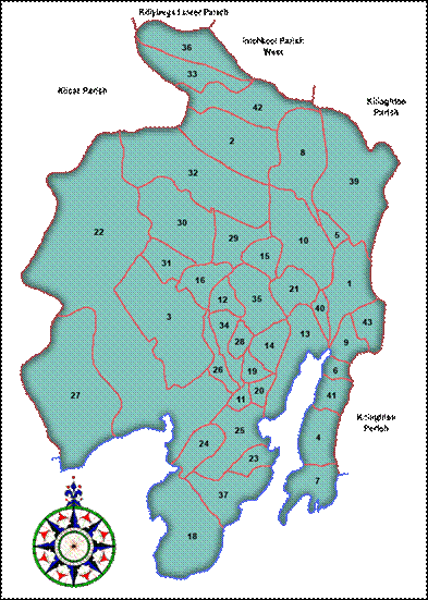
County Donegal
This Ulster coastal county, which is largely bog and mountain land, contains the towns of Letterkenny, Donegal, Ballyshannon, Lifford, Stranorlar, Killybegs, and Bundoran. In 1837 the following description was written about Killybegs:
KILLYBEGS, a sea-port, market, and post-town, and a parish, (formerly a parliamentary borough), partly in the barony of BOYLAGH, but chiefly in that of BANNAGH, county of DONEGAL, and province of ULSTER, 38 miles (S. W.) from Lifford and 127 miles (N. w.) from Dublin, on the road from Ballyshannon and Donegal town to Rutland ; containing 4287 inhabitants, of which number, 724 are in the town. County Donegal contains 4,830 square kilometers of land. (Compare this to Brule County, South Dakota, which has 2,192 square kilometers of land with 5,364 people. McPherson County, South Dakota, has 2,983 square kilometers of land but only 2,904 people. Ireland was densely populated prior to the famine.)
The parish, from which a portion (38 townlands) has been separated to form the district parish of Ardara, is for civil purposes distinguished into Upper and Lower Killybegs. It comprises, according to the Ordnance survey, 30,962 ½ statute acres, of which 4304¼ are in that part of Lower Killybegs, which is in the barony of Boylagh ; 11,074¼ , including a detached portion, and 51 covered with water, are in the other part, in the barony of Bannagh ; and 15,583¾ , including 41¾ covered with water, are in Upper Killybegs, and the barony of Bannagh : 30,160 statute acres are applotted under the tithe act, of which about two-thirds are mountain and uncultivated land : agriculture is in a very unimproved state.
Murrin Facts
A Murrin family moved from Killybegs to America in approximately 1730. This family included a Lt. William Murrin who was a Pennsylvania quartermaster at Valley Forge with Washington.
Murrin and Moran claim to come from the same family line, and appear to be variations of an earlier name (Moran — O Móráin, "big, great". Murrin. Connacht).
Family Tree
Why should we know where our ancestors lived? Armed with this information we can find out how they lived, a description of the land they inhabited, and a starting point for further genealogical research. The following shows our family tree from County Donegal. We are kin to this family through Adelaide McGonigle. Adelaide McGonigle married Francis S. Ryan of Kimball, South Dakota. Adelaide’s mother was born Catherine Murrin. According to family lore our great ancestor, Francis McGonigle, knew Catherine Murrin in County Donegal, and renewed his friendship with her in America.

![[home]](tims_research3_files/image004.gif)
The Griffith Valuation Survey
The first modern census for Ireland began in 1821 and a census was taken every 10 years. War and fires destroyed most Irish census records, and the earliest records to be found are dated 1901. Due to this lack of census information genealogists rely on ‘census substitutes’ such as the Griffith Valuation Survey when seeking distant relatives. Had the census records survived this survey would have been long forgotten.
The Murrin Family
The Murrin families were thick as blackbirds down in this part of County Donegal. The following index comes from the Griffith Valuation Survey taken between 1847 and 1864 and it shows twenty six Murrin names listed. Some of these names are duplicates as we shall see later. James Murrin was father to Catherine Murrin and grandfather to Adelaide McGonigle. Look at the list below. Six ‘James Murrin’ entries are listed; however, five ‘James Murrin’ entries remain after eliminating duplicates.
Which ‘James Murrin’ entry refers to our great ancestor? Several facts need to be considered. First, we know Francis McGonigle and Catherine Murrin knew each other in Donegal; therefore, it would seem reasonable that they lived close enough to have known each other. Second, we find one entry for ‘Peter McGonigle’ in Upper Killybegs, which was in Drumbarity townland. Peter McGonigle was Francis McGonigle’s father. Catherine Murrin’s family was from Upper Killybegs too.
According to the 1910 US Census, Francis McGonigle immigrated to America in 1869. Catherine Murrin immigrated a few years earlier in 1865. The birth year listed in the census for Francis was 1847 and for Catherine it was 1846. If the census is correct then Catherine was about 19 years old when she came to America. In 1865 Francis would have been 18 years old. Family lore says he was 19 years old when he immigrated in 1869. In that case he would have been 15 years old in 1865.
The following pages attempt to locate Catherine’s family when they lived in Ireland. The following chart lists all the Murrin surnames found in the Griffith Valuation Survey taken in the mid-nineteenth century. The name, James Murrin, appears six different times however, this refers to only five different people.
|
|||||||||||||||||||||||||||||||||||||||||||||||||||||||||||||||||||||||||||||||||||||||||||||||||||||||||||||||||||||||||||||||||||||||||||||||||||
|
Townlands
Since at least the medieval period, every county and parish has been divided into small land units known generally as townlands. These units were formerly called by a variety of local and regional names, such as "balliboes" in parts of Ulster, "tates" in Fermanagh and Monaghan, and "ploughlands" in some southern counties. Despite frequent enlargement and division, the basic townland pattern has survived to the present day. Varying in size from a few acres to several thousand in area, townlands average 1.3km2, large enough to contain a number of farms whose owners were kin and traditionally co-operated in various ways. Townland boundaries are often marked by streams or deep ditches, banks and old hedges. Numbering more than 65,000 in the 1851 Townlands Index for all Ireland, the townlands no longer have significance as units of social and agrarian life, but in a country of dispersed rural settlement where farms lack individual names, the ancient units still have use for conveying topographical information and for postal addresses. Townlands are characteristically larger and elongated in elevated areas but dense on the lowlands, and their orientation tends to reflect the local variations in land contour. The townland was and is the smallest officially recognized geographical unit in rural Ireland.
 |
|
The Murrins of Carricknamoghil
The following information shows where Michael Murrin lived in Killybegs Civil Parish. He lived in Carricknamoghil townland, which was several townlands away from Drumbarity townland. Drumbarity was where Peter McGonigle lived. From Drumbarity you walk northeast through Croaghlin townland. After leaving Croaghlin you enter Faiafannan townland, where you continue traveling northeast until you reach Carricknamoghil. It is difficult to determine the distance between these two points; however, it may be a mile or two at the most.
|
||||||||||||||||
 |
||||||||||||||||
 |
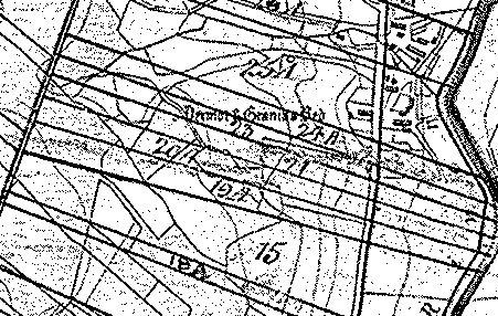 |
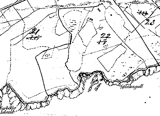
Upper Portion of Carricknamog Townland
Lower Portion of Carricknamog Townland
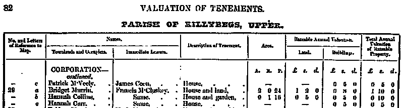
The Murrins of Corporation Townland
Corporation Townland abuts Killybegs townland, which also includes Killybegs market town. Three Murrins lived in this townland: Patrick, Bridget and Edward. Although the list above indicates Edward Murrin lived in this townland, we could not find a reference for him. The following shows copies of the Griffith Valuation Survey that include Patrick and Bridget Murrin. Patrick (house and land) occupied 5 acres of land. Bridget (house and land) occupied 2 acres of land.
|
||||||||||||||||
 |
||||||||||||||||
 |
||||||||||||||||
 |
||||||||||||||||
 |
||||||||||||||||
|
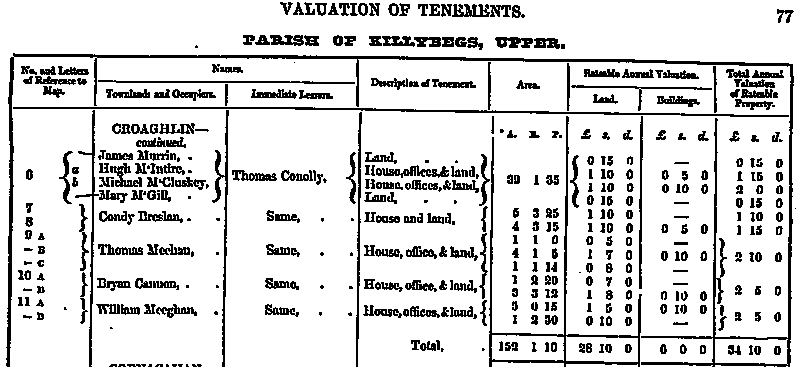
The Murrin Family of Croaghlin Townland
Two Murrin families lived in this townland: James Murrin and Thomas Murrin. It appears four people also shared land in Section 6 – James Murrin, Hugh McIntire, Michael McCluskey and Mary McGill. Why is this interesting? Catherine Murrin’s mother was born Bridget McCloskey. This ‘James Murrin’ entry may be our great ancestor since Peter McGonigle lived only a few farmlands away in Drumbarity townland. Family lore says Francis McGonigle and Catherine Murrin were friends in Ireland. Too great of a distance would have made them acquaintances at best. From one farmland to the other the distance may be 1/8 to ¼ mile. If I were a betting man I would place my wager on this location as the likeliest where Catherine Murrin lived. It is very likely Peter McGonigle and this James Murrin knew each other.
|
||||||||||||||||
 |
||||||||||||||||
 |
||||||||||||||||
 |
 |
|
The Murrins of Drumanoo (or Drumano) townland
The following Murrins lived in this large townland: Bryan, James, Mary, Robert, Bridget, Hannah, Patrick Sr., and Patrick Jr. These were the heads of household for the Murrin families living in this area of County Donegal. Drumanoo appears to be where there the largest concentration of Murrins was found in Upper Killybegs Civil Parish. There is a James Murrin living in this townland but it is some distance from Drumbarity townland where Peter McGonigle lived. From Drumbarity one would travel south to get to Drumanoo. You would pass through the following townlands before reaching Drumanoo: Drumbeagh, Cashelcummin, Killybegs, Glebe and Roshin.
|
||||||||||||||||
 |
||||||||||||||||
 |
||||||||||||||||
 |
 |
In Section 4 one finds Bryan and James Murrin. Section 5 lived James Murrin and Mary Murrin. Section 6 lived Robert Murrin and Bridget Murrin.
Below, Patrick Murrin was a tenant on Section 15a. Hannah Murrin lived in Section 16.
|
 |
 |
***